
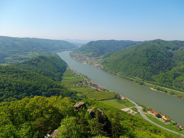
The Danube valley between the cities of Melk and Krems is known as “Wachau”. It is about 36 km long section of the river “Danube”. Seen from west to east, the Wachau begins in Melk at the Danube, from the city of Vienna it begins in Krems at the Danube.
Which places belong to the Wachau?
From the 14th century, the section between the Mießlingbach near Spitz and the Watstein near Dürnstein was called “Wachau”. This concerned originally only the places St. Michael, Wösendorf, Joching and white churches. These places were summarized in 1972 to the large community “white churches in the Wachau”.
The Wachau – the new limit
At the end of the 19th century, a new boundary was defined, which made the cities of Melk on the Danube and Krems an der Donau the new “gates”.
Places along the Danube – in the north
The following places are located in this Danube valley on the left / north bank of the Danube. We start just opposite the city of Melk, in the locality “Emmersdorf”. To this municipality also belong the places Luberegg, Gossam, Grimsing and Schallemmersdorf. Worth seeing here is especially the castle Luberegg. The viewpoint is the Dachbergwarte.
Then the community Aggsbach follows with Aggsbach market and Groisbach. Aggsbach market was already mentioned in 830 in a document of Louis the Pious as “Accussabah”. The next municipality is world-well-known above all by the find of the “Venus of Willendorf”.
In the next town “Schwallenbach” begins the community “Spitz an der Donau”, which is very popular with tourists or as a destination. The most famous excursion tips are the Thousand-Minute Mountain, the Red Gate and the ruin Hinterhaus.
In the heart of the Wachau is St. Michael, small and distinguished by its historical significance. The Romanesque stone church, which was rebuilt over the centuries to a late-Gothic church and a fortification is definitely worth a break. The municipality of Weißenkirchen then also include Wösendorf and Joching. Weißenkirchen itself is also a much sought-after holiday tip and, in addition to the vineyards with the Wachaufestspiele and the Wachau Museum, also offers a good cultural offer.
Internationally, Dürnstein is probably the most well-known term in connection with the Danube valley. The ruin and the castle or the pin are a fixed part of every tourist. The villages Oberloiben and Unterloiben belong to the municipality Dürnstein now offer a good active offer.
The conclusion of the community list “Danube downstream” is Stein an der Donau and Krems at the danube. Here is the more than 1,000-year history can still be seen today. The old town offers many insights, cultural centers, museums and baroque buildings.
Places along the Danube – in the south
The following places are located down the Danube on the right / south bank.
The best known is probably the town of Melk with the baroque pen. It is also considered the landmark of the Wachau.
The Danube downstream comes then the community Schönbühel-Aggsbach. In the village Schönbühel is located on a high rock. Above the village Aggsbach-Dorf perched the ruin Aggstein.
The community Rossatz – Arnsdorf includes the places …. Oberarnsdorf, Hofarnsdorf. Mitterarnsdorf, Bacharnsdorf, St. Lorenz, Rührsdorf, Rossatz and Rossatzbach. Here you will find large apricot gardens (Marillenmeile), vineyards and Donauuauen, perfect for walks and hikes. The Danube can be reached at Spitz / Arnsdorf (car-bicycle-person ferry), Weißenkirchen / St. Lorenz (car bicycle -u. Passenger ferry) and at Dürnstein / Rossatzbach (bicycle and passenger ferry) cross. Mautern The municipality Mautern consists of Hundsheim, Mauternbach and Mautern. A bridge connects Mautern with stone. Mautern was already inhabited in Roman times, worth seeing are the Roman Museum and the city center. From Mautern you can reach the Göttweig Abbey. In Mautern begins the Wachauer Jakosbweg.
Map – Location of the Krems-Wachau region
The map shows the location of the Wachau region, where the Danube meanders through the Danube valley. To the west (in the left part of the map) is the town of Melk. In the east (in the right part of the map) the city of Krems.
Sie sehen gerade einen Platzhalterinhalt von Standard. Um auf den eigentlichen Inhalt zuzugreifen, klicken Sie auf den Button unten. Bitte beachten Sie, dass dabei Daten an Drittanbieter weitergegeben werden.
Mehr InformationenThe viticulture area “Wachau”
The name “Wachau” is also used for the winegrowing area. However, the wine-growing region begins on the northern shore at Schwallenbach and ends in Loiben (on the southern shore at Mauternbach / Hundsheim).


